
Web
and Book design,
Copyright, Kellscraft Studio 1999-2016 (Return to Web Text-ures) |
 (HOME)
|
CHAPTER III
THE GREAT SMOKY MOUNTAINS
For a long time my chief interest was not in human neighbors, but in the
mountains themselves — in that mysterious beckoning hinterland which rose right
back of my chimney and spread upward, outward, almost to three cardinal points
of the compass, mile after mile, hour after hour of lusty climbing — an Eden
still unpeopled and unspoiled. I loved of a morning to
slip on my haversack, pick up my rifle, or maybe a mere staff, and stride forth
alone over haphazard routes, to enjoy in my own untutored way the infinite
variety of form and color and shade, of plant and tree and animal life, in that
superb wilderness that towered there far above all homes of men. (And I love it
still, albeit the charm of new discovery is gone from those heights and gulfs
that are now so intimate and full of memories). The Pinnacles or serrated
ridges are rare. There are few commanding peaks. From almost any summit in Characteristic, too, is the
dreamy blue haze, like that of Indian summer intensified, that ever hovers over
the mountains, unless they be swathed in cloud, or, for a few minutes, after a
sharp rain-storm has cleared the atmosphere. Both the Blue Ridge and the The foreground of such a
landscape, in summer, is warm, soft, dreamy, caressing, habitable; beyond it
are gentle and luring solitudes; the remote ranges are inexpressibly lonesome,
isolated and mysterious; but everywhere the green forest mantle bespeaks a
vital present; nowhere does cold, bare granite stand as the sepulchre of an
immemorial past. And yet these very
mountains of The richness of the Great
Smoky forest has been the wonder and the admiration of everyone who has
traversed it. As one climbs from the river to one of the main peaks, he passes
successively through the same floral zones he would encounter in traveling from
mid-Georgia to southern Starting amid sycamores,
elms, gums, willows, persimmons, chinquapins, he soon enters a region of beech,
birch, basswood, magnolia, cucumber, butternut, holly, sourwood, box elder,
ash, maple, buckeye, poplar, hemlock, and a great number of other growths along
the creeks and branches. On the lower slopes are many species of oaks, with
hickory, hemlock, pitch pine, locust, dogwood, chestnut. In this region nearly
all trees attain their fullest development. On north fronts of hills the oaks
reach a diameter of five to six feet. In cool, rich coves, chestnut trees grow
from six to nine feet across the stump; and tulip
poplars up to ten or eleven feet, their straight trunks towering like gigantic
columns, with scarcely a noticeable taper, seventy or eighty feet to the
nearest limb. Ascending above the zone of
3,000 feet, white oak is replaced by the no less valuable “mountain oak.”
Beech, birch, buckeye, and chestnut persist to 5,000 feet. Then, where the
beeches dwindle until adult trees are only knee-high, there begins a sub-arctic
zone of black spruce, balsam, striped maple, aspen and the “Peruvian” or red
cherry. I have named only a few of
the prevailing growths. Nowhere else in the temperate zone is there such a
variety of merchantable timber as in western The undergrowth is of
almost tropical luxuriance and variety. Botanists
say that this is the richest collecting ground in the It was the botanist who
discovered this And we of a later age,
seeing the same wild gardens still unspoiled, can appreciate the almost religious
fervor of those early botanists, as of Michaux, for example, who, in 1794,
ascending the peak of Grandfather, broke out in song: “Monté au sommet de la
plus haut montagne de tout l’Amérique Septentrionale, chante avec mon
compagnon-guide l’hymn de Marsellois, et crié, ‘Vive la Liberté et la
République Française!’” Of course Michaux was
wildly mistaken in thinking Grandfather “the highest mountain in all For a long time there was
controversy as to whether Mount Mitchell or Clingman Dome was the crowning
summit of eastern In any case, the Great
Smoky mountains are the master chain of the Appalachian system, the greatest
mass of highland east of the Although some parts of the
Smokies are very rugged, with sharp changes of elevation, yet the range as a
whole has no one dominating peak. Mount Guyot (pronounced Gee-o, with g
as in get), Mount LeConte, and Clingman Dome all are over 6,600 feet and under
6,700, according to the most trustworthy measurements. Many miles of the divide
rise 6,000 feet above sea-level, with only small undulations like ocean swells.
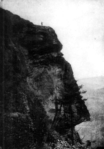 Photo by U. S. Forest Service “There are few jutting crags” — Southeast profile of The most rugged and
difficult part of the Smokies (and of the In August and September,
1900, Mr. James H. Ferriss and wife, naturalists from “We bought another axe of a
moonshiner, and, with a week’s provisions on our backs, one of the guides and I
took the Consolidated American Black Bear and Ruffed Grouse Line for “A surveyor had run part of
the line this year, which helped us greatly, and the
bears had made well-beaten trails part of the way. In places they had mussed up
the ground as much as a barnyard. We tried to follow the boundary line between
the two States, which is exactly upon the top of the Smokies, but often missed
it. The government [state] surveyor many
years ago made two hacks upon the trees, but sometimes the linemen neglected to
use their axes for half a mile or so. It took us three and one-half days to go,
and two and one-half to return, and we arose with the morning star and worked
hard all day. The last day and a half, going, there was nothing to guide us but
the old hacks. “Equipped with government
maps, a good compass, and a little conceit, I thought I could follow the
boundary-line. In fact, at one time we intended to go through without a guide.
A trail that runs through blackberry bushes two miles out of three is hard to
follow. Then there was a huckleberry bush reaching to our waists growing
thickly upon the ground as tomato vines, curled hard, and stubborn; and laurel
much like a field of lilac bushes, crooked and strong as iron. In one place we
walked fully a quarter of a mile over the tops of laurel bushes and these were
ten or twelve feet in height, but blown over one way
by the wind. Much of the trail was along rocky edges, sometimes but six inches
or so wide, but almost straight down on both sides for hundreds of feet. One
night, delayed by lack of water, we did not camp till dark, and, finding a
smooth spot, lay down with a small log on each side to hold us from rolling out
of bed. When daylight came we found that, had we rolled over the logs, my
partner would have dropped 500 feet into Even to the west of
Clingman a stranger is likely to find some desperately rough travel if he
should stray from the trail that follows the divide. It is easy going for
anyone in fair weather, but when cloud settles on the mountain, as it often
does without warning, it may be so thick that one cannot see a tree ten feet
away. Under such circumstances I have myself
floundered from daylight till dark through heart-breaking laurel thickets, and
without a bite to eat, not knowing whither I was going except that it was toward
the In 1906 I spent the summer
in a herders’ hut on top of the divide, just west of the Locust Ridge
(miscalled Chestnut Ridge on the map), about six miles east of Thunderhead.
This time I had a partner, and we had a glorious three months of it, nearly a
mile above sea-level, and only half a day’s climb from the nearest settlement.
One day I was alone, Andy having gone down to Medlin for the mail. It had
rained a good deal — in fact, there was a shower nearly every day throughout
the summer, the only semblance of a dry season in the Smokies being the autumn
and early winter. The nights were cold enough for fires and blankets, even in
our well-chinked cabin. Well, I had finished my
lonesome dinner, and was washing up, when I saw a man approaching. This was an
event, for we seldom saw other men than our two selves. He was a lame man,
wearing an iron extension on one foot, and he hobbled with a cane. He looked
played-out and gaunt. I met him outside. He smiled as though I looked good to
him, and asked with some eagerness, “Can I buy
something to eat here?” “No,” I answered, “you
can’t buy anything here” — how his face fell! — “but I’ll give you the best we
have, and you’re welcome.” Then you should have seen
that smile! He seemed to have just
enough strength left to drag himself into the hut. I asked no questions, though
wondering what a cripple, evidently a gentleman, though in rather bad repair,
was doing on top of the “I am a Canadian, I liked his grit. “I knew no place to go,” he
continued; “so I took a map and looked for what might be interesting country,
not too far from I broke in abruptly:
“Whoever told you that was either an impostor or an ignoramus. There are only
four of these shacks on the whole Smoky range. Two of them, the Russell cabin
and the Spencer place, you have already passed without knowing it. This is
called the Hall cabin. None of these three are occupied save for a week or so
in the fall when the cattle are being rounded up, or by chance, as my partner
and I happen to be here now. Beyond this there is just one shack, at Siler’s
Meadow. It is down below the summit, hidden in timber, and you would never have
seen it. Even if you had, you would have found it as bare as a last year’s
mouse nest, for nobody ever goes there except a few bear-hunters. From there
onward for forty miles is an uninhabited wilderness so rough that you could not
make seven miles a day in it to save your life, even if you knew the course;
and there is no trail at all. Those government maps are good and
reliable to show the approaches to this wild country, but where you need
them most they are good for nothing.” “Then,” said he, “if
I had missed your cabin I would have starved to death, for I depended on
finding a house to the eastward, and would have followed the trail till I
dropped. I have been out in the laurel thickets, now, three days and two
nights; so nothing could have induced me to leave this trail, once I found it,
or until I could see out to a house on one side or other of the mountain.”  The Bears’ Home — “You would see no house on either side from
here to beyond Guyot, about forty miles. Had you no rations at all?” “I traveled light,
expecting to find entertainment among the natives. Here is what I have left.” He showed me a crumpled buckwheat
flapjack, a pinch of tea, and a couple of ounces of brandy. “I was saving them for the
last extremity; have had nothing to eat since yesterday morning. Drink the
brandy, please; it came from “No, my boy, that liquor
goes down your own throat instanter. You’re the chap that needs
it. This coffee will boil now in a minute. I won’t give you all the food you
want, for it wouldn’t be prudent; but by and by you shall have a bellyful.” Then, as well as he could,
he sketched the route he had followed. Where the trail from Of animal life in the
mountains I was most entertained by the raven. This extraordinary bird was the
first creature Noah liberated from the ark — he must have known, even at that
early period of nature study, that it was the most sagacious of all winged
things. Or perhaps Noah and the raven did not get on
well together and he rid himself of the pest at first opportunity. Doubtless
there could have been no peace aboard a craft that harbored so inquisitive and
talkative a fowl. Anyway, the wild raven has been superlatively shy of man ever
since the flood. Probably there is no place
south of If the raven’s body be
elusive his tongue assuredly is not. No other animal save man has anything like
his vocal range. The raven croaks, clucks, caws, chuckles, squalls, pleads,
“pooh-poohs,” grunts, barks, mimics small birds, hectors, cajoles — yes, pulls
a cork, whets a scythe, files a saw — with his throat. As is well known, ravens can be taught human speech, like
parrots; and I am told they show the same preference for bad words — which, I
think, is quite in character with their reputation as thieves and butchers.
However, I may be prejudiced, seeing that the raven’s favorite dainties for his
menu are the eyes of living fawns and lambs. A stranger in these
mountains will be surprised at the apparent scarcity of game animals. It is not
unusual for one to hunt all day in an absolute wilderness, where he sees never
a fresh track of man, and not get a shot at anything fit to eat. The cover is
so dense that one still-hunting (going without dogs) has poor chance of spying
the game that lurks about him; and there really is little of it by comparison
with such huntings fields as the Adirondacks, “The most striking feature
of the forest, after one has become habituated to the gloom, the pathlessness,
and the apparent impenetrability of the screen it forms around him, is the
absence of animal life. You may wander for hours without seeing a living
creature.... One thinks of the woods and the wild beasts; yet in
all the years of my wilderness living I can catalogue the wild creatures other
than squirrels, grouse, and small birds (never plenty, generally very rare)
which I have accidentally encountered and seen while wandering for hunting or
mere pastime in the wild forest; one deer, one porcupine, one marten (commonly
called sable), and maybe half a dozen hares. You may walk hours and not see a
living creature larger than a fly, for days together and not see a grouse, a
squirrel, or a bird larger than the Canada jay.... Lands running with game are
like those flowing with milk and honey; and when the sporting books tell you
that game is abundant, don’t imagine that you are assured from starvation
thereby. I have been reduced, in a country where deer were swarming, to live
several days together on corn meal.” It is much the same to-day
in our Appalachian wilderness, where no protection worthy the name has ever
been afforded the game and fish since Indian times. There is a class of
woods-loafers, very common here, that ranges the forest at all seasons with
single-barrel shotguns or “hog rifles,” killing bearing females as well as legitimate
game, fishing at night, even using dynamite in the streams; and so, in spite of
the fact that there is no better game harborage granted by Nature on our
continent than the Carolina mountains, the deer are all but exterminated in
most districts, turkeys and even squirrels are rather scarce, and good trout fishing is limited to stocked waters or streams flowing
through virgin forest. The only game animal that still holds his own is the
black bear, and he endures in few places other than the roughest districts,
such as that southwest of the The only venomous snakes in
the mountains are rattlers and copperheads, the former common, the latter rare.
The chance of being bitten by one is about as remote as that of being struck by
lightning — either accident might happen, of course. The mountaineers
have an absurd notion that the little lizard so common in the hills is rank
“pizen.” Oddly enough, they call it a “scorpion.” From those two pests of the
North Woods, black-flies and mosquitoes, the Smokies are mercifully exempt. At
least there are no mosquitoes that bite or sting, except down in the river
valleys where they have been introduced by railroad trains — and even there they
are but a feeble folk. The reason is that in the mountains there is almost no
standing water where they can breed. On the other hand, the
common house-fly is extraordinarily numerous and persistent — a daily curse, even on top of Smoky. I imagine this is due
to the wet climate, as in In most years there are
very few chiggers, except on pine ridges. They are worse along rivers than in
the mountains. The ticks of this country are not numerous, and seldom fasten on
man. The climate of the In general the mornings are
apt to be lowery, with fogs hanging low until, say, 9 o’clock, so that one
cannot predict weather for the day. Heavy dews remain on the bushes until about
the same hour. The winters are short. What
Northerners would call cold weather is not expected until Christmas, and
generally it is gone by the end of February. Snow sometimes falls on the higher
mountains by the first of October, and the last snow may linger there until
April (exceptionally it falls in May). Tornadoes are unknown here, but
sometimes a hurricane will sweep the upper ranges. On April 19, 1900, a
blizzard from the northwest struck the Smokies. In twenty minutes everything
was frozen. At Siler’s Meadow seventeen cattle climbed upon each other for
warmth and froze to death in a solid hecatomb. A herdsman who was out at the
time, and narrowly escaped a similar fate, assured me that “that was the
beatenest snowstorm ever I seen.” In the valleys there may be a few days in
January and February when the mercury drops to zero
or a few degrees lower. On the high peaks, of course, the winter cold often is
intense, and on the sunless north side of Clingman there are overhangs or
crevices where a little ice may be found the year around. 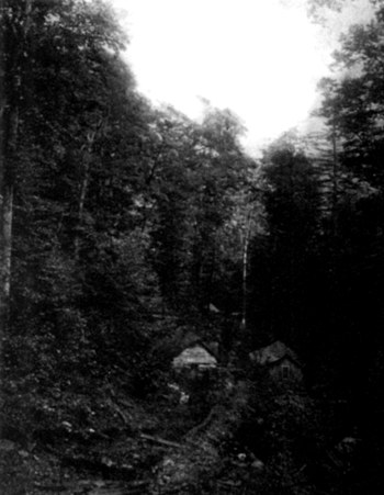 The old copper mine Undoubtedly there is vast
mineral wealth hidden in the ______________ 2 Average annual rainfall of
|
 Click the book image to turn
to the next Chapter.
Click the book image to turn
to the next Chapter.